

5. Lammefjord
The Lammefjord was in the beginning of the 1900’Th century embanked and drained, which has resulted in a fertile area located in northwest Zealand in Odsherred municipality. The pilot area represents a low lying area covering 2897 ha. The terrain, drainage of the soil, and the relatively high clay percentage in the soil makes the area favorable for intense agriculture. This is also the dominating land use in the area, whereas nature outside agriculture covers a much smaller area.
Download a complete PDF version here.

Map: Geographical location of the pilot area Lammefjord.
LAND USE
The main land use in the Lammefjord is intensive agriculture (74 %) followed by urban areas (13.2 %) and nature areas outside agriculture such as forest, water, and open nature (6 %) (map and table). The area thereby represents – together with Hagen Moellebaek – the pilot areas with the highest ratio of agriculture (Hagens Moellebaek = 82.8 %) and the lowest area of nature outside agriculture (Hagens Moellebaek = 3.2 %) (figure).
Land use is illustrated on the map and the belonging table for the Lammefjord below. Furthermore, land use for the 7 pilot areas is illustrated in the figure.

Map: Land use in the pilot area the Lammefjord in 10×10 meters resolution.
Table: Land use in the Lammefjord in hectare (ha) and share of total area in percent (%).
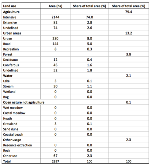
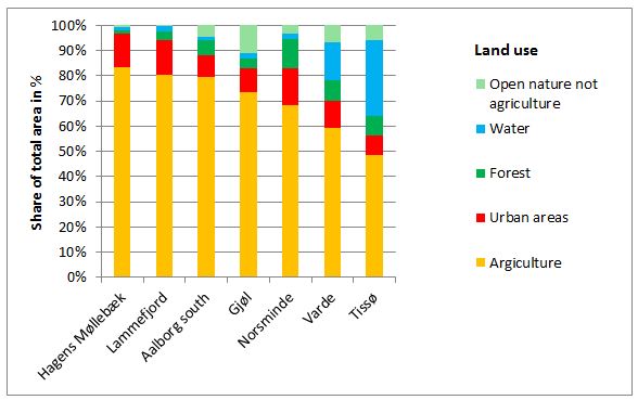
Figure: Land use in the 7 pilot areas described as share of total area in percent (%). The pilot areas are listed to % agriculture.
SOIL
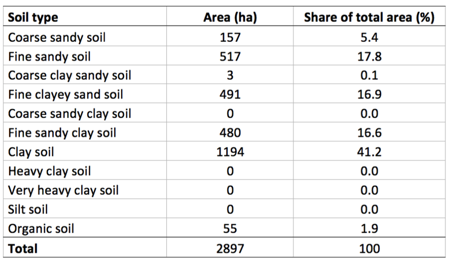
Overall the western soils of Denmark contain a high sand percentage whereas the eastern parts are dominated by the more heavy soils – clay (map 1). The Lammefjord is located in eastern Denmark and is also dominated by the clayey and fertile soils (58 %) (map 2 and table).
The soil types of the pilot area are illustrated on map 2 and the belonging table below.

Map 1: Soil type in Denmark.
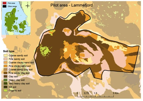
Map 2: Distribution of soil types in the pilot area the Lammefjord in 30.4×30.4 meters resolution.
Table: Distribution of soil types in the pilot area the Lammefjord in hectare (ha) and share of the total area in percent (%).
TOPOGRAPHY
With an elevation from -7 to 10 meters above the sea level (map 1) and a slope of the terrain from -7 to 10 meters the Lammefjord is one of the lowest lying areas in Denmark. This makes the area suitable for agriculture.
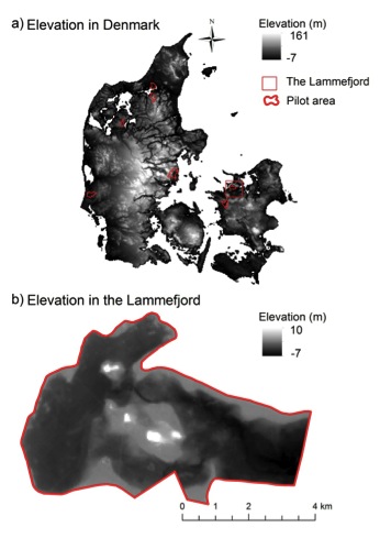
Map 1: Elevation in Denmark (a) and in the pilot area the Lammefjord (b) in 48×48 meters resolution.
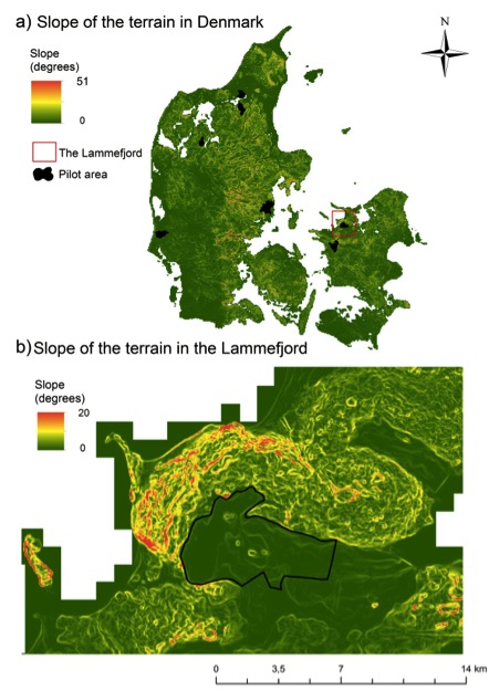
Map 2: Slope of the terrain in Denmark (a) and in the pilot area the Lammefjord (b) in 48×48 meters resolution
HYDROLOGY
Wetness is here illustrated by the topographical wetness index. The wetness index calculates how much water a given point in the terrain potential can receive (the size of the catchment) in relation to its ability to drain itself (slope of the terrain). The index expresses the ability of the point to accumulate water. It is based alone on placement of the point in the terrain and the shape of the terrain, and does not include other factors such as soil type, precipitation, etc.
The pilot area is delineated by the delta of the Lammefjord and is a relatively wet area.
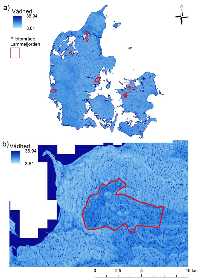
Map: Topographical wetness index in Denmark (a) and in the pilot area the Lammefjord (b) in 48×48 meters resolution.


 Danish